Highlight


Handcol. engr., 47 x 57 cm, depicting an armillary sphere, a celestial globe and a terrestrial globe, Nuremburg, J.B. Homann, ca. 1720, framed und...
Handcol. engr., 47 x 57 cm, depicting an armillary sphere, a celestial globe and a terrestrial globe, Nuremburg, J.B. Homann, ca. 1720, framed und...
Du déjeuner Pullman au diner. Paris-Bruxelles-Amsterdam. Paris, Hachard & Cie, 1927. 106 x 75 cm. Corners and minor dam. to folds, professionally ...
A large vintage 1950s (1959) sales promotion wall hanging map of the British Isles. Scale 1:633,600 or 10 miles per inch. Measures approx 150x170c...
ASHER AND ADAMS Asher & Adams' New Historical and Topographical Atlas of the United States. With Maps Showing the Dominion of Canada, Europe and t...
BLAEU (JAN) Delfi Batavorum vernacule Delft, hand-coloured engraved double-page plan of the city of Delft, Latin text on verso, remnants of archi...
BLAEU (WILLEM AND JAN) Toonneel des Aerdrycz, oft Nieuwe Atlas... Tweede Deels, 2 parts in 1 vol., engraved architectural and allegorical titles ...
BLAEU (WILLEM AND JAN) Toonneel des Aerdrycks oft Nieuwe Atlas...Vierde Deel, engraved title and 58 engraved maps, marginal damp-staining, small ...
BRADFORD (THOMAS G.) A Comprehensive Atlas, Geographical, Historical & Commercial, hand-coloured pictorial frontispiece, engraved decorative titl...
GRAY (O.W.) Gray's Atlas of the United States, with General Maps of the World, numerous hand-coloured lithographed maps (some double-page, usuall...
Two 20th Century reproduction maps of South-West interest, featuring a map of 'Somersetshire', dated '1836', and a map of 'Gloucestershire'. Both ...
LINFORTH (JAMES, EDITOR) Route from Liverpool, to Great Salt Lake Valley Illustrated...by Frederick Piercy, FIRST EDITION, 30 engraved plates and...
SPEED (JOHN) The Kingdome of China Newly Augmented by I.S. 1626, hand-coloured engraved map, decorated borders with eight costumed figures in ver...
MITCHELL (SAMUEL AUGUSTUS) A New Universal Atlas Containing Maps of the Various Empires, Kingdoms, States and Republics of the World. With a Speci...
MITCHELL (SAMUEL AUGUSTUS) Mitchell's New General Atlas, Containing Maps of the Various Countries of the World, Plans of Cities, Etc., 59 hand-co...
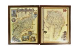
NORFOLK and SUFFOLK SPEED (JOHN) Norfolk, a Countie Florishing & Populous Described and Devided with the Armes of such Noble Familes as have Borne...
SOCIETY FOR THE DIFFUSION OF USEFUL KNOWLEDGE The Complete Atlas of Modern, Classical and Celestial Maps, together with Plans of the Principal Cit...
SPEED (JOHN) AND WILLEM BLAEU Pictorial title-pages to Speed's 'Theatre of the Empire of Great Britain', 1650, and Blaeu's 'Le Théâtre du Monde......
SPEED (JOHN) Yorkshire; The North and East Ridings of Yorkshire, inset plans of Hull and Richmond; The West Ridinge of Yorkeshyre with Most Famou...
FRENCH REVOLUTION - LOUIS XVI Document signed and subscribed by the King ('Bon Louis'), and his secretary, ordering Joseph Duruey, Administrator o...
Gerard de Jode (Nimega 1509 - Anversa 1591), “Roman Empire - Four Kingdoms”. Lotto composto da quattro incisioni su carta, H cm 20x29 (difetti) ...
Lt Col. Valentine Blacker CB. (British, 1778-1826) Satara from the NNE inscribed and dated '11th February 1818' pen & ink 23 x 14cm (9 1/16 x 5 1...
AFRICA MUNSTER (SEBASTIAN) Africa Lybia Morenlandt mit allen königreichen so zu unsern zeiten darin gefunden werden, hand-coloured woodcut map, l...
AFRICA BLAEU (WILLEM) Africae nova descriptio, hand-coloured engraved double-page map, 10 costumed figures on the vertical margins and 9 oval vig...
LONDON STOW (JOHN) A Survey of the Cities of London and Westminster... Corrected, Improved, and Very Much Enlarged... to the Present Time; by John...
AFRICA HONDIUS (HENRICUS) Africae nova Tabula, double-page hand-coloured engraved map, numerous ships, sea-monsters, animals (elephants, lions, c...
AFRICA L'Afrique suivant les dernières observations de M. Hass et des RR. PP. Jésuites, engraved map with hand-coloured outlines, light toning,49...
AFRICA DE WIT (FREDERICK) Totius Africae Accuratissima Tabula, hand-coloured double-page engraved map, decorative title cartouche, animal vignett...
WEST AFRICA HONDIUS (JODOCUS) Guineae Nova Descriptio, hand-coloured engraved double-page map, title cartouche and inset map of St. Thomas, Frenc...
WEST AFRICA DE WIT (FREDERICK) Tractus Littorales Guineae a Promontorio Verde usque ad Sinum Catenbelae, hand-coloured engraved double-page map, ...
ETHIOPIA ORTELIUS (ABRAHAM) Presbiteri Iohannis, sive, Abissinorum Imperii Descriptio, hand-coloured engraved double-page map, large cartouche wi...
EAST AFRICA DE WIT (FREDERICK) Occidentalior Tractus Indiarum Orientalium a Promontorio Bonae Spei ad C. Comorin, hand-coloured engraved double-p...
ETHIOPIA, SOUTH AFRICA AND MADAGASCAR BLAEU (WILLEM) Aethiopia Superior vel Interior vulgo Abissinorum sive Presbiteri Joannis Imperium, hand-col...
A collection of seven 20th century Conic Projection maps together with another. The lot to include: the map of Iran (Persia) scale 1:4,000,000 pla...
(Utrecht, 1606 - Anversa, 1684)Natura mortaOlio su tela, cm 80X112Provenienza: Probabilmente Parigi, Galleria Charpentier (1956, come attribuito a...
BERNADIN DE SAINT PIERRE (JACQUES) A Voyage to the Isle of France, the Isle of Bourbon, and the Cape of Good Hope, half-title, 4 hand-coloured fo...
Schleswig Holstein. Nordfriesland. Original kolorierte Kupferstichkarte von Joh. Mejer aus C. Danckwerth, Newe Landesbeschreibung ..., 1652. 2 Kar...
[CHATELAIN (HENRY ABRAHAM)] Atlas historique, ou nouvelle introduction a l'histoire..., vol. 6 (with Africa section only), title printed in red a...
Saxton, Christopher (c.1540-c.1610) & William Hole (d. 1624) - A 17th century etched & hand coloured map of Oxfordshire. The map reading: Oxoniens...
ROGERS (WOODES) A Cruising Voyage Round the World: First to the South-Sea, thence to the East-Indies, and Homewards by the Cape of Good Hope, Begu...
THAILAND and EAST ASIA TACHARD (GUY) Reis Na Siam edaan door den Ridder de Chaumont, in't Nederduitsch gebracht door G. V. Broekhuizen, additiona...
Alessandro Stefani Argentiere, Scatola ovale in argento con interno in vermeil, Bologna, XX secolo. Superficie riccamente lavorata a cesello e sba...
Norwegen Karte18.Jh.Tractus Norvegiae Suecicus Praefecturam Bahusiae finitimaeque Daliae provinciae partem.- Teilkolor. Kupferstich, ersch. bei Jo...
Paar Karten der Küste von Norwegen18.Jh.Dabei: Paskaert van de Cust van Noorwegen erschienen bei Johannes van Keulen, Paskaert voor een gedeelte v...
Karte der Ostsee18.Jh.Tabula Hydrographica Maris Baltici.- Teilkolor. Kupferstich, ersch. bei Johannes Janssonius. Mittelfalz. Leicht nachgedunkel...
Ostsee Karte18.Jh.Paskaart voor een Gedeelte van de Oost Zee.- Teilkolor. Kupferstich, erschienen bei Johannes van Keulen. Mittelfalz. Leicht nach...
Karte des Skagerraks17./18.Jh.Pascaarte vant Schager-Rack vande Pater-nosters aen Kol. als mede de Sondt: oock hoe dese landen van Schagen gelegen...
Karte v. Dänemark u. Südschweden18.Jh.Nieuwe Afteekening van de Sond ant Groot.- Kupferstich, erschienen bei Gerard van Keulen. Mehrfach gefalzt. ...
Dänemark Karte18.Jh.Regni Daniae.- Grenzkolor. Kupferstich, ersch. bei Johann Baptist Homann. Mittelfalz. Leicht nachgedunkelt/fleckig/wellig, lei...
Ostsee Karte18.Jh.De Oost Zee of Öster Siöön.- Teilkolor. Kupferstich, ersch. bei Gerard van Keulen. Nachgedunkelt/gebräunt/fleckig/lichtrandig, K...
Ostsee Karte18./19.Jh.Et nyt Pas=Kaart over Sundet og begge Belterne.- Teilkolor. Kupferstich, ersch. bei Christian Carl Lous. Mehrfach gefalzt. L...
David Michael Jones (1895-1974) Map of the Third Voyage wood engraving 19 x 16cm.
Reisen. Deutschlandkarte. Roost, J. B. Neue Wand – Karte von Deutschland den Königreichen Holland u. Belgien und der Schweiz, sammt den angrenzend...
Var. sizes. Comprises Hameleers II, 305 (17th ed., 1920), 342 (1st and 5th or 13th edition, 1919 and 1931 or 1932), 359 (5th ed., 1932), 370 (3rd ...
Amsteldam ten tweede mael vergroot (...) inden jaere 1482. Ca. 1671-1680. 26 x 31 cm. Fully backed w. thin Japan paper, otherwise very fine. Hamel...
Handcol. engr. plan, 41 x 54 cm, framed under deluxe passepartout. Hameleers I, 29, third ed., w. the address of Joan Blaeu.
Handcol. engr. plan, 15.5 x 23 cm. Hameleers I, 27, second ed. -and 4 others, all 18th cent. (total 5)
Handcol. etched plan, 27.5 x 38.5 cm. Hameleers 19, unstated ed., w. one page of Latin text and page no. 10 verso.
19th century A.D. Printed map of Egypt and Nubia with locations marked of the sketches of David Roberts, RA on his 1849 expedition; mounted in a g...
Handcol. etched plan, 34 x 48 cm, framed under deluxe passepartout. Hameleers I, 7, first ed.
Handcol. engr. plan, 47 x 56.5 cm, framed under passepartout. Hameleers I, 75, first ed., w. address of Gerard Valk in lower left corner. Rare.


![BLAEU (JAN) Delfi Batavorum vernacule Delft, [Amsterdam, 1649 or later]; BLAEU (WILLEM) Novus X...](https://portal-images.azureedge.net/auctions-2024/bonham10855/images/73460c6e-1380-48e8-bc29-b179011a54d5.jpg?h=175)


![SPEED (JOHN) Yorkshire; The North and East Ridins of Yorkshire; West Ridinges, [c.1730], hand-co...](https://portal-images.azureedge.net/auctions-2024/bonham10855/images/38d5b31b-fc81-4c30-82bb-b179011a54ac.jpg?h=175)


![AFRICA BLAEU (WILLEM) Africae nova descriptio, [c. 1630 or later]](https://portal-images.azureedge.net/auctions-2024/bonham10791/images/d70693cb-2c26-42a3-9d72-b17a010d6222.jpg?h=175)


![WEST AFRICA HONDIUS (JODOCUS) Guineae Nova Descriptio, [Amsterdam, after 1619]; BLAEU (WILLEM) G...](https://portal-images.azureedge.net/auctions-2024/bonham10791/images/60cf56e9-8579-461d-a2ef-b17a010d721a.jpg?h=175)


![CHATELAIN (HENRY ABRAHAM)] Atlas historique... vol. 6 (with Africa section only), 1719; and 3 ot...](https://portal-images.azureedge.net/auctions-2024/bonham10791/images/042d00a5-0aa0-4a70-95b3-b17a010d9cce.jpg?h=175)


